Stage description
You’ll use Google Street View to navigate around a sprint course, answering a question at each control.
Recommended device
Desktop computer or laptop with separate mouse.
Details
Google Street View provides interactive panoramas of streets from all around the world, allowing you to travel along the street as if you were really there. If you haven’t used it much before, we recommend trying it out before attempting the stage. See Google’s instructions for using Street View.
Warm-up
You can try our Street View Orienteering course around Chester, from the Easter Champs. However, we’ve changed the format for this stage: you will need to remain in Street View at all times (more like real orienteering!).
The stage
The stage will be available from 00:01 BST on Friday 24th April.
The course will have 10 controls. You’ll need to visit the 10 controls and the finish, and answer a question about what you find at each location.
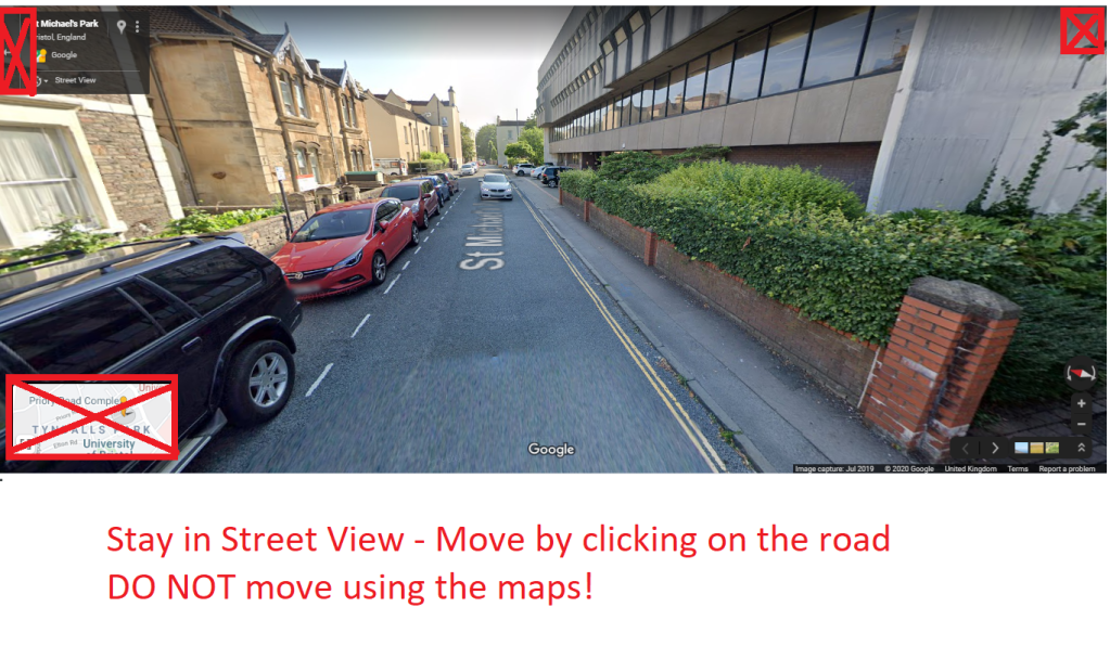
We’re trying to make this a realistic simulation of orienteering (as far as we can!). You have to remain in Street View. Do not use the map view to move around. When you’re in Street View, move your mouse over the road until an arrow or square appears, and then click to change your position. The further down the road you click, the further you travel! Note – Street View on this area is only available on the roads.
At the end you’ll be ranked by:
- firstly, how many questions you got right
- then, the total time you took to answer the questions
When you’re ready to play:
- Go to this link. Your time starts as soon as you click on the link!
- Enter your name and competition number.
- You’ll see a form containing the questions, and two links: one link will open the orienteering map, and the other will take you to the start point in Google Street View.
- Visit each control and the finish in Street View, and answer a question about what you find at each location. You must navigate between the controls in Street View.
- When you’ve answered all the questions, press Submit to finish.
When you’ve submitted your answers to all the questions, the stage is complete – we’ll do the rest 🙂
You MUST complete the stage by 20:00 BST on Saturday 25th April.
If you have any issues, please contact us.
Results
We’ll rank everyone’s results in order. First place gets 1000 points, second place 999 points, third place 998 points, and so on. If you miss the deadline for completing the stage, you’ll lose 50 points (unless your lateness is caused by the organisers).
Sponsors
Big thanks to our sponsors:
- CompassPoint – orienteering equipment
- JWOC 2021 – providing maps for the Sprint Weekend
- Mitchell Maps – the official UK OCAD reseller. You can get 20% off OCAD subscriptions until the end of May plus free support when you buy through Mitchell Maps
- Sprint Scotland – sprint racing and training in Scotland
- Forest Challenge Game – orienteering board game
- Catching Features – offering a 40% discount to all competitors
